
Marcus Stafford
I'm a Designer
About

Geospatial Programmer and Analyst
- Degrees: GIS, History, Geography, Anthropology, MAGIST
- Email: marcusstafford.ms@gmail.com
- Skills: R, Python, JavaScript, GIS
- Education: Arizona State University and UCLA
My name is Marcus Stafford, and I am a GIS professional specializing in R, Python, JavaScript, and data analysis. I earned a degree in GIS from Arizona State University and am currently enrolled in the MAGIST program at UCLA. Please have a look at my portfolio, and reach out for any questions or inquiries. Here, I will demonstrate my knowledge and ability with GIS software, programming, and data analysis.
Resume
University Education
Master of Applied Geospatial Information Systems and Technologies
2023 - 2025
University of California, Los Angeles
Bachelor of Science, Geographic Information Science
2021 - 2023
Arizona State University
- Summa cum laude (with the highest distinction) honors
Bachelor of Arts, History
2021 - 2023
Arizona State University
- Summa cum laude (with the highest distinction) honors
Bachelor of Science, Geography
2021 - 2023
Arizona State University
- Summa cum laude (with the highest distinction) honors
Bachelor of Arts, Anthropology
2021 - 2023
Arizona State University
- Summa cum laude (with the highest distinction) honors
Professional Expereince
GIS Technician
2023 - Present
Actalent
- Responsibilities included ensuring accurate GIS information from mapping to electrical standards. Updating and confirming GIS asset information from our ArcGIS Online system to in-field GIS asset information. Work included reading and understanding utilities information. Inlucdes transformers, poles, service wires, underground cables.
Archeological Research Assistant
2022 - 2023
Arizona State University, School of Human Evolution and Social Change, Tempe, Arizona
- Contributed to the Teotihuacan Mapping Project in the. This project was funded by the National Science Foundation. The main focus of the project was to organize, categorize and understand past archelogical records relating to urban planning artifact distribution, and living and planning conditions of ancient Teotihuacan.
Portfolio
Below you will find various projects that I have completed using Python, R, and Javascript. In addition, GIS software ArcMap, ArcGIS Online, and ArcGIS Pro.
- All
- GIS Maps
- JavaScript/HTML
- Python
- R
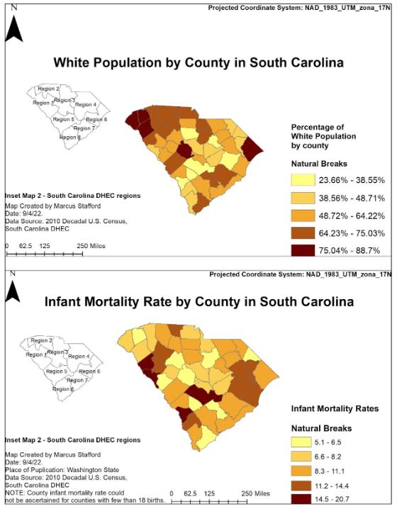
Mortality Rate in South Carolina
Another GIS Map Example
Example #8
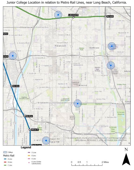
Population living near metro bus stops, in relation to community colleges
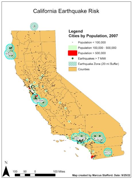
Earthquake risk in the state of California
Python Project Example
Example #10
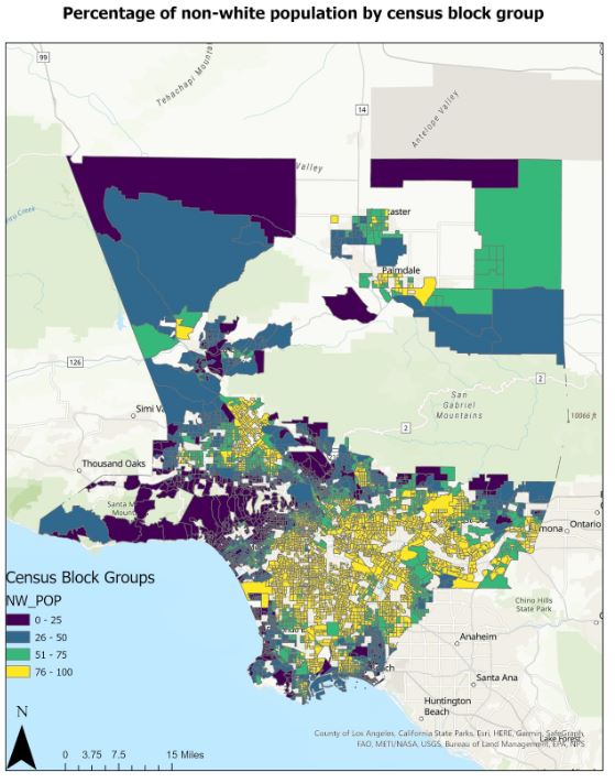
Population distribution in Los Angeles County